Our Winter Vacation '04 - Page 3
 |
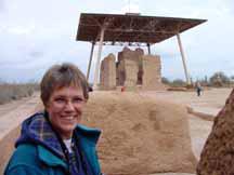 |
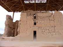
On our first excursion, we went to the prehistoric ruins at the Casa Grande National Monument, about 15 miles from the RV Park. Here, there is an imposing 4-story building dating from the late Hohokam Indian period (in the 1300's) that is contempary with other ruins in Arizona such as the Tonto and Montezuma Castle Monuments. It is located between the Gila and Santa Cruz rivers near Coolidge, Arizona. The "Big House", as it is called, can be seen from some distance and has a rather distinctive look as it is protected by a large metal roof structure supported by 4 large pillars. The building is 60 by 40 feet wide at the base and has 4 1/2 foot thick walls built of caliche mud with supporting wooden beams. It is situated in a compound of outlying buildings enclosed in a rectangular wall. At least three other similar compounds and four detached clan houses once stood in the area near by. Some have speculated that Casa Grande was a kind of astronomical observatory as the four walls face the points of the compass, and some holes in the walls are aligned to the positions of the sun and moon at specific times. Evidently, in prehistoric days, this was an important center of the local population and of an agricultural society of farmer laborers, with evidence of an extensive irrigation system clearly visible nearby. Coronado passed by it in 1540 and then the Spaniard Fray Marcos first saw it in 1539 when he called it Chichilticalli. In November of 1694, the famous Jesuit priest Father Eusebio Francisco Kino (who founded the Mission San Cayetano de Tumacacori, which is north of Nogales) searched for the ruins, found them, and said a mass within it's walls. It is believed the Hohokam Indians abandoned the site in the mid 1500s, as part of the decline in their civilization. Apart from other Indian peoples, others did not revisit this area until the 1880's when American settlers arrived and began to threaten the ruins by removing artifacts for souvenirs and carving their names on the walls. In 1892, Casa Grande became the first archeological site in the USA to be protected as a National Monument.
 |
 |
 |
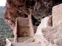 |
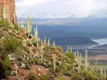
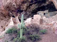
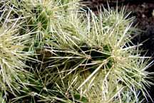
Our next excursion was a long-one day drive through some really interesting and beautiful country. We set out toward the east traveling past the Casa Grande National Monument to Florence, Florence Junction, and then the copper mining towns of Superior, Miami, and Globe on route 60. We discovered in these last three towns that Arizona has a rich history of mining with long stretches of mine tailings in many places. From Globe, we headed northwest on highway 88 (the Apache Trail) toward Roosevelt Lake. We then took a detour off the highway to Tonto National Monument and the Tonto Cliff Dwellings. We arrived in the area too late to take the guided tour to the upper dwellings (which require reservations), but we were able to take the self guided tour of the lower dwellings which is reached by a steep uphill hike extending a half mile up a paved trail from the parking lot. These well-preserved cliff dwellings were occupied by the Salado Indian culture between 1150 and 1450. The people farmed in the Salt River Valley below (which is now occupied by Roosevelt Lake) and added to their diet by hunting and gathering native plants. The Salado were superior craftsmen, producing some of the finest polychrome pottery and woven textiles to be found in the Southwest. On the trail to the site, we were able to identify many of the common Arizona plant species such as the Saguaro, Cholla, Prickly Pear, Hedgehog and Barrel Cactus; the Yucca, Sotol, and Agave; the Creosote Bush and Ocotillo; and the Palo Verde and Mesquite trees. The Cholla Cactus is very deceiving because it looks very soft and inviting to the touch (it is also known as the "teddy bear cactus") and has a pleasing yellow-brown to light-green appearance consisting of a dense covering of spines. However, we found that this cactus must definitely not be touched as the spines have a peculiar way of jumping into your skin at just the slightest touch. After reaching the lower dwelling, it was possible to scramble around the various rooms and then ponder what it must have been like for those people to live in such a place (and how they were able to avoid the Cholla in their skimpy clothing). What they did have, however, were some great views of the valley below from their mountainous perch.
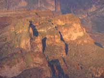 |
From the entrance to Tonto National Monument, we traveled another 4 miles west to Roosevelt Dam and the beautiful large bridge, which spans the waters just in front of the dam. Before turning southwest and heading past the dam, we crossed the bridge and then turned back and recrossed it so that we could fully appreciate the beauty of the area. The bridge is the longest two-lane, single span, steel-arch bridge in North America. The dam was originally completed in March of 1911, and dedicated by Theodore Roosevelt for whom it was named. It was, at that time, the world's highest masonry dam, and the lake behind it the world's largest artificial lake. The dam has since been enlarged and remodeled, having been completed in 1996. Heading south and mostly west past the dam toward Apache Junction and Phoenix, we traveled down what has been called "the most scenic road in Arizona". Theodore Roosevelt had traveled on it to the dedication of the dam and proclaimed that, "The Apache Trail combines the grandeur of the Alps, the glory of the Rockies, the magnificence of the Grand Canyon, and then adds something that none of the others have. To me, it is the most beautiful panorama nature has created." This has been designated a historic road and it covers some of the most rugged terrain in Arizona. Steep sided canyons, rock outcroppings, and magnificent geologic formations are all along the road. Fish Creek Canyon was the most awe-inspiring section for us. This canyon is over 1000 feet deep, with towering walls and ledges spotted with giant saguaro cacti. The road begins a very steep climb up the side of this high-walled canyon to its top and winds its way along tremendous precipices that plummet for hundreds of feet below, all on a narrow dirt road (one way in places) without guard rails. At one time, hardy fools used to race their teams of horses down this track with many of them flying off into the voids of space before officials put an end to this caper. This road is unpaved for 20 miles between the dam and Tortilla Flat, and we were glad we had our jeep to navigate the twists and turns through the contorted canyons and washes. After reaching Tortilla Flat, a place that looked like a wild west way stop, we stopped for a bite to eat at the saloon there. This place had saddles for bar stools and the walls were papered with thousands of one-dollar bills; truly unique.
 |
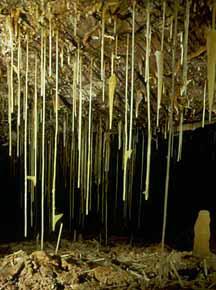 |
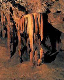
Our next adventure was to the Kartchner Caverns and to the town of Tombstone. The caverns are about 50 miles east of Tucson and 9 miles south from Interstate 10 and the town of Benson. Reservations are required to visit the caves, with two 1/2 mile long guided tours available. We called ahead the day before and we were able to reserve the 9:00 am Rotunda/Throne Room tour. The Big Room cave tour had already been sold out for several months in advance. The caves were discovered in 1974 by two amateur cavers who then kept their find secret for 4 years before telling the owner of the property. In 1988, the location was officially announced to the public as Kartchner Caverns, named after the rancher who owned the land. In November of 1999, the extremely well preserved caverns were opened to the public as Kartchner Caverns State Park, after 28 million dollars had been spent to insure that the caverns would have minimal impact from visitors who number between 500,000 to 700,000 to the park each year. It was easy for us to see that a huge amount of money was spent to provide access to visitors. From the beautifully designed headquarters (with grand exhibits), visitors climb aboard an electric train of tramcars, which carries them to the cave where they dismount before entering large air locks at the cave entrance. A heavy mist is sprayed down upon visitors at the entrance to discourage dust and microbes from discharging from them on the tour. All the walkways within the cave are cement covered with stainless handrails placed where needed. All visitors are strongly lectured on the "do-nots" before entering and they are closely monitored through out the tour. Inside the caverns, darkness and humidity prevail. In fact, it was actually stifling when first entering the cave, compared to the cooler outside morning air we had come from. The humidity was 99 % and the temperature was 68 degrees. The presentation of the "live" cave and the narration provided by the guide was excellent and we were able to see some spectacular features (besides the usual stalactites and stalagmites) such as the 1/4 inch wide by 21 foot long calcite "soda straw", and formations such as translucent orange bacon draperies, helectites, quartz boxwork, brushite moonmilk, popcorn, shields, totems and cascades of flowstone. The feature presentation was the 58-foot high column called the Kubla Khan. Visitors take a seat on a platform overlooking the Throne Room where music (Adiemus) soon begins and then lights begin to play up, down, and around the flutings of the column in time with the music. Quite impressive!
 |
 |
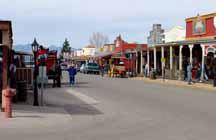 |
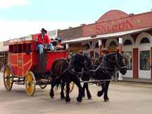
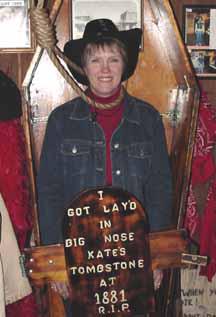
After our tour of the caves, we decided to head for Tombstone, the place renowned for its mining history and for the "gunfight at the OK Corral" in 1881. A drive of about 30 miles brought us into town where we soon found ourselves seated in the Big Nose Kate's Saloon having lunch and being entertained by a guitar-playing singer. This saloon is full of the old west character as is all of Tombstone. The interior has a rustic look, with stained glass windows, and bar maids dressed in appropriate outfits of yesteryear. After lunch, we took our time and roamed the town investigating places such as the Bird Cage Theatre, the Crystal Palace Saloon, and Boot Hill.
 |
 |
 |
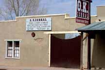
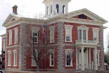
The famous gunfight actually took place near the intersection of Third Street and Fremont Street in a vacant lot 90 yards behind the OK Corral and between Fly's Boarding House/Photo Studio and the Jersey's Livery Stable. The Earp brothers considered the Clanton gang to be a lawless bunch (as were many of the thieves, gamblers, and rustlers who were attracted to Tombstone) and decided to take it upon themselves to arrest and disarm the gang after receiving numerous threats from them. So, the Earp brothers (Wyatt who was deputy sheriff, Morgan who was a city policeman, and Virgil who was a deputy marshal), along with John Henry "Doc" Holliday confronted the Clantons (Ike and Billy) who were with Frank and Tom McLowery and Billy Claiborne. The quick 30 second shootout left Billy Clanton and the McLowery brothers dead, left Virgil and Morgan Earp with serious wounds, and Doc Holliday with a bullet graze. Soon after, the bodies of Billy Clanton and the McLowery brothers were displayed in their Sunday best, resting in coffins that were propped up in the front window of the local undertaker's parlor with a sign that said, "Murdered on the streets of Tombstone". The Earps and Doc Holliday were arrested by county Sheriff Behan (who was in the pay of the Clantons and whose former girlfriend, Josie, now belonged to Wyatt) for murdering the three gang members, but it was determined at the trial that they had acted within the law. All this occurred within four years from when a prospector, Ed Schieffelin, staked his mining claim here in 1877 after being told by comrades that he would only find his "tombstone" before finding silver. When rumors of this rich strike got around, the "boom town" of Tombstone developed overnight with Ed's adopted name for it. In 1879, the town was incorporated and in 1880 the first railroad was completed between the town and Tucson. In 1881, a telegraph was connected to all points in the area, and The Bird Cage Theatre opened to a town that now hosted over 6,000 people. The Cochise County courthouse was completed in 1882, and in just a few short years the town doubled in size. A rough and tough civilization sprang to life in a very short period of time and in an area where there had been nothing but scrub brush only a few years previous. This is truly an interesting place that is filled with much history.
 |